
EMMA DAVE
- Laurene
- Aug 23, 2025
- 2 min read


The other day I was looking through old newspaper files when I came across this piece of information;
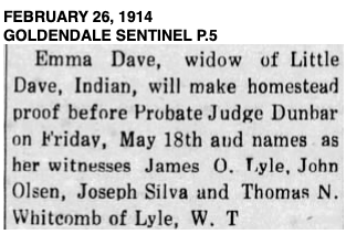
I thought it interesting that four early Klickitat County settlers felt it was important for Emma Dave to make her homestead claim. Why? and
Where was this homestead claim?
BLM gave this record:

A modern day map shows her land as Native American Land in the area of Fisher Hill Bridge.
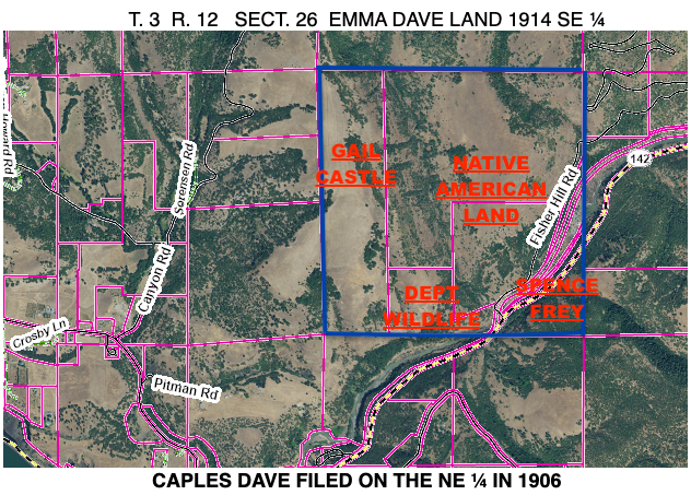
Caples Dave was the son of Emma and Little Dave and he actually filed earlier than Emma.
After realizing this land was in the area of Fisher Hill Bridge, I remembered bits and pieces of power companies involved in a lawsuit with a Native woman. When Jerry Dean gave his talk at the Pioneer Meeting about early plans for water in the Glenwood Valley, he mentioned an effort to dam the Klickitat River, which came to an end when the power company lost their suit against a Native woman.
1913 MAP OF THE AREA.
YOU CAN SEE WHERE THE RAILROAD BRIDGE CROSSES THE KLICKITAT.
THE BALFOUR LAND WAS THE ORIGINAL JAMES O. LYLE FARM.
CLAUSE AND MARTHA STAACK LATER OWNED THIS FARM.
THE STRATTON LAND IS THE FARM GARVER AND ANNIE CASTLE PURCHASED.
CAPLES DAVE AND EMMA DAVE ARE IN THE AREA OF FISHER HILL ROAD AND BRIDGE, including the east side of the River.

I could not find an obituary for Little Dave. Emma was a widow in 1911, so he passed away before that.

In 1927 Emma's home burned:

Emma Dave passed away in 1939. She was around 100 years old.


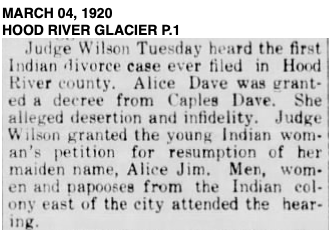
Caples Dave married Alice Jim in Hood River in 1911. They divorced in 1920.

This photo is from Historic Hood River. I don't know if this is the Alice Jim that was married to Caples Dave.
Caples Dave passed away in 1948.


Comments