GLENWOOD WASHINGTON
INFO & WEATHER
Glenwood, WA is located
in the northwestern portion of
Klickitat County. It borders Yakima County.
The community is in the Glenwood Valley, formerly known as Camas Prairie. It is part of the Yakama Reservation.
We have a splendid view of Mt Adams.
Even though the mountain appears to be
in our back yard, it is actually in Yakima and
Skamania counties.
Lat: 46.0095°N Lon: 121.2715°W
The elevation of my weather station is 1854 ft.

CHIEF SPENCER was from the Klickitat/Chinook Tribe. When Kamiakin refused to return to the Reservation, Spencer was appointed as Chief of the Yakama Nation.
His family was killed by Whites in the Cascades area. He
lived to be over 105 years old.
Chief White Swan succeeded Chief Spencer.

From the Yakama Nation History
"First Chief of the Yakama Nation 1856-1861
Chief Spencer's tribal name was "Tah pa shah" and interpreted to Sharp Shooter. He was Chief of the Klickitats and appointed at the original Yakama Agency in White Swan, Washington. He was confirmed by J.W. Nesmith, Superintendent of Indian Affairs for the Washington-Oregon Territory in 1856.
He was also appointed by U.S. officials since Chief Kamiakin refused to come onto the reservation. Chief Spencer was paid $500 per year and at the end of his appointment was given an officer's sword."
CHIEF SPENCER, STICK JOE, INDIAN ABRAHM LINCOLN
THREE MEMBERS OF THE YAKAMA NATION WHO WORKED
ON THE RESERVATION BOUNDARY
CLICK ON THEIR NAME TO LEARN MORE ABOUT THEM
Some 1900 documents state that he was originally from California.
From the book, "An Illustrated History of Klickitat, Yakima and Kittitas Counties" page 166 Stick Joe is a scout for Agent Wilbur and helps locate the missing Spencers who were murdered in 1878. History Link.org
I haven't found a photo yet of Stick Joe. Both Chief Spencer and Stick Joe had knowledge of early boundary markers for the Yakama Reservation. Chief Spencer refers to Agent Townsend who was Agent of the temporary White Salmon Reservation which included Camas Prairie.
In 1899, E.C. Barnard was assigned to review and survey portions of the Yakama Reservation boundary.
Below is his report.
NOTE: Abe Lincoln joins them. He is a guide well acquainted with the country and the claims of the Indians. Abe Lincoln is also the one who came to Glenwood to meet surveyor Chester Pecore in 1923 to show him the blazed trees where the Indian Trail meets the road to Goldendale
I haven't completed the White Swan Page. He moved from Vancouver to the White Salmon Reservation. From there he moved to the Yakama Reservation.
He was in contact with Isaac Stevens.
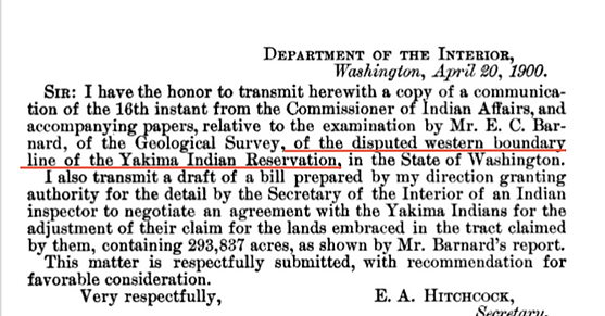
THIS IS AN INTRODUCTION TO THE PURPOSE AND RESULTS OF THE BARNARD SURVEY
NOTE THAT IN THE YEAR APRIL 1900, E.C. BARNARD'S FINDINGS WERE APPROVED AND THERE WAS TO BE AN ADJUSTMENT TO THE INDIANS FOR THE TRACT CLAIMED OF 293,837 ACRES ON THE WESTERN BOUNDARY
United States Congressional serial set, Issue 3997 PAGE 1
https://books.google.com/books?id=34Q3AQAAIAAJ&dq=stick+joe+yakima+indian&source=gbs_navlinks_s


ON PAGE 3 MR BARNARD GIVES AN ACCOUNT OF HIS TRIP :


The rest of page 4 and page 5 deal with the results of the findings, the existing boundary does not conform to the findings and conclusions by W. A. Jones The Secretary of The Interior.
The second half of page 6 begins with E.C. Barnard describing his travels to study the western boundary:

PAGE 7: I find this fascinating reading as they come down the west side of the Klickitat and up to the Goldendale road to the blazed trees.
This is in the area of Outlet. Years later Abe Lincoln came back to the area to show surveyor Pecore the blazed tree.

The second half of page 7 with Stick Joe's description of when he had accompanied a party along the southern boundary in 1860


PAGE 8: BARNARD IS CONVINCED THAT STICK JOE AND CHIEF SPENCER KNOW WHAT THEY ARE TALKING ABOUT AS FAR AS THE BOUNDARY MARKERS FOR THE SOUTHERN SURVEY.
BOTH INDIANS ARE AWARE OF BOUNDARY MARKERS IN 1859-1860.
NOTICE ALSO THAT BARNARD MENTIONS THAT TOWNSEND WAS AGENT OF THE WHITE SALMON RESERVATION IN 1858. MY PERSONAL OPINION IS THAT SOUTH OF THE 46TH PARALLEL, CAMAS PRAIRIE WAS PART OF THE TEMPORARY WHITE SALMON RESERVATION.

SECOND HALF OF PAGE 8


A PORTION OF PAGE 9

THE ABOVE IS AN EXCERPT FROM E.C. BARNARD'S 1900 SURVEY REPORT. CHIEF SPENCER, STICK JOE AND ABRAHAM LINCOLN KNEW WHERE THESE OLD 1858-1859 GOVERNMENT BLAZES WERE.
IN 1923, SURVEYOR CHESTER PECORE COMES INTO THE GLENWOOD VALLEY TO COMPLETE MORE SURVEY WORK FOR THE RESERVATION. ABRAHAM LINCOLN MAKES A TRIP TO GLENWOOD TO SHOW HIM THE TREES.
THE OLD INDIAN TRAIL CROSSED THE KLICKITAT IN THE AREA OF TODAY'S KLICKITAT SALMON HATCHERY.
McCLELLAN'S SURVEY PARTY IN 1853 FOLLOWED THIS TRAIL
THE PECORE SURVEY OF SOUTH EAST BOUNDARY AFTER INDIAN ABRAHAM LINCOLN SHOWED HIM THE BLAZED TREE BOUNDARY MARKERS. THESE WOULD BE THE SAME BOUNDARY MARKERS THAT CHIEF SPENCER AND ABE LINCOLN HAD TOLD SURVEYOR BARNARD ABOUT IN 1899. ALSO SHOWN IS THE CAMPBELL LINE. PECORE'S LINE INTERSECTS WITH CAMPBELL'S LINE AT GOAT BUTTE.
FROM WHAT I CAN GATHER, AT LEAST, THREE NATIVE AMERICANS WERE AWARE OF THE BLAZED BOUNDARY MARKERS WHERE THE OLD FORT SIMCOE TRAIL INTERSECTS THE GOLDENDALE ROAD ON T.6 R13 AND WERE IN AGREEMENT THAT THE LINE THEN ANGLED TO GOAT BUTTE.
FROM THE RESEARCH FILES OF JERRY OLSON
THE CHESTER PECORE SURVEY:
The third survey was in 1923 of a continuation of the West and North Boundaries of the Yakima Indian Reservation as part of Group 56. Pecore had been there in 1920 to change a survey made in 1907. The 1907 survey basically went from Grayback Mountain to Goat Butte, in a straight line, and from Goat Butte to Spencer Point in a straight line.
Pecore had instructions to put an angle point in the line from Grayback to Goat Butte at the location of some blazes found by the Indians at the Glenwood Road and an old Indian trail, a short distance East of Glenwood. Pecore enlisted an Indian, Abraham Lincoln, to point out the blazes.
He then created a straight line from Grayback Mountain to the blazes, and another from the blazes to Goat Butte. He then projected the old Reservation line from Goat Butte to the crest of the Cascades, a short distance, to a point on the North slope of Mt. Adams.
PAGE 12 FROM PECORE SURVEY AND ANOTHER "THIS TREE IS A YELLOW PINE

A MAP SHOWING THREE RESERVATION BOUNDARY LINES. THE 1890 SCHWARTZ LINE, THE CAMPBELL LINE. CHESTER PECORE'S LINE AND THE NEW QUESTIONABLE BOUNDARY TO THE SOUTH.
THE BELOW MAP IS FROM:
USGS Scientific Investigations Map 3315 pamphlet
Geologic Map of the Simcoe Mountains Volcanic Field, Main Central Segment, Yakama Nation, Washington
By Wes Hildreth and Judy Fierstein.
IT SHOWS THE SCHWARTZ, CAMPBELL AND THE PECORE LINE.
IN RED, IT SHOWS THE NEW LINE. SO FAR, I HAVE NOT FOUND ANY DOCUMENTATION BY THE OLD NATIVE AMERICANS, CHIEF SPENCER, STICK JOE OR ABRAHAM LINCOLN THAT THE BOUNDARY LINE SHOULD CONTINUE SOUTH AND WEST TO INCLUDE THE GLENWOOD VALLEY. THEY ACCEPTED THAT THE LINE RAN TO GOAT BUTTE.
ALTHOUGH LITTLE MT ADAMS SEEMS MORE OF A CONNICAL LAND MARK IN RESERVATION DESCRIPTIONS THAN GOAT BUTTE.

A COPY OF THE 1913 MAP, SHOWING TOWNSHIP 6 RANGE 13, WITH PECORE CAMPING SPOT, OLD INDIAN TRAIL, GOLDENDALE ROAD AND APPROXIMATE LOCATION OF TREE BLAZES WHICH CHIEF SPENCER, STICK JOE AND ABRAHM LINCOLN IDENTIFIED.
I INCLUDED A MAP OF RANGE 12 WITH GLENWOOD, WHICH LIES DIRECTLY WEST OF RANGE 13, SO YOU COULD FAMILIARIZE WITH THE TERRAIN

A SIDE NOTE. NOTICE THE PARCELS OF LAND ALONG THE KLICKITAT RIVER OWNED BY WM. R. KING AND B.B. WATSON. WILLIAM KING WAS A RESIDENT OF NEW JERSEY BUT CHIEF ENGINEER AND DEVELOPER OF THE KLICKITAT VALLEY DEVELOPMENT CO. FOR THE PURPOSE OF PRODUCING AND TRANSMITTING ELECTRICITY AND IRRIGATION WATER. B.B. WATSON WAS HIS SISTER IN LAW BERTHA WATSON.
I suspect the blazed trees, east of Glenwood, the junction of the Old Indian Trail and road to Goldendale were on the 46th parallel. Note the below report of the Yakima District boundaries.
From the United States Senate Documents Volume 112

EXTRA READING

